
Whitsunday District (Ext)
Locations
Maps
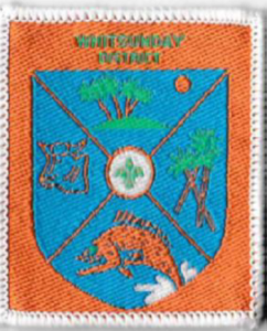
Badge Description
Scout logo
Fish = Fishing industry
Palm Trees = Tourism island destination
Sugar cane = Sugar cane planting
Cow = Cattle industry
Previous Badge Variations
The following are variations of the badge:
 |
|
Woven bound |
|
50 x 60 mm |
| Ext |
History
Whitsunday district is named after the Whitsunday Passage, which was named by Captain James Cook. Based on his journal date, Cook believed that the passage was discovered on Whit Sunday, the Sunday of the feast of Whitsun, Pentecost in the Christian liturgical year which is observed 7 weeks after Easter. Whitsunday district was formed in 2000 [1]. The last mention of Whitsunday District was in Issue 2 of the 2004 Central & Coastal Region Newsletter [2]. The District Commissioner at the time was Greg Walker [2]. The District Commissioner in 2003 was Wayne Harm. The Whitsunday District Campsite “Bundaleer” was at Peter Faust Dam, Proserpine [3]. The Branch database records indicate that the district was de-registered on 21st April 2008 [4].
Groups
Whitsundays District Groups (2003): Proserpine Scout Group, Whitsunday Coast Scout Group, Bowen Scout Group, Collinsvale Scout Group, Glenden Scout Group [4}
Whitsundays District Groups (2004): Proserpine Scout Group, Whitsunday Scout Group, Bowen Scout Group, Collinsvale Scout Group [2]
References
- Cross, L. (17th November 2017). Queensland Badge Club. Personal communique
- Central & Coastal Region Newsletter. Issue 1 2004, April Edition
- Central and Coastal Region (2003). Newsletter, Issue 1 (March), p. 1.
- Scouts Australia, Queensland Branch. Electronic archive database retrieved 6th May 2018